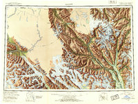
1952 Map of Skagway
USGS Topo · Published 1953About this map
The White Pass and Yukon Route railway climbs through the coastal mountains of Southeast Alaska in this 1950s survey, connecting the port at Skagway to the interior. The landscape is defined by massive glacial systems, including the Grand Pacific Glacier and Muir Glacier, which flow toward the deep waters of Taiya Inlet and Chilkat Inlet. The settlement pattern follows the river valleys and protected harbors, with Haines and Port Chilkoot serving as maritime gateways near the Chilkoot Cem. Inland, the Chilkat River provides a corridor toward the native settlement of Klukwan and the mining area of Porcupine. This map records the region after the establishment of the Glacier Bay National Monument Boundary, illustrating the complex border relationship between Alaska and the Yukon Territory and British Columbia.
Find a feature on this map
115 named features on this map. Tap any name to fly to it.
Don’t see what you’re looking for? This feature index may not catch every label — zoom into the map to look around manually.
Map Details
Editions of this 1952 Skagway Map
4 editions found

Other maps of this area

1948 · Skagway C-4
USGS Topo · 1:63,360

1948 · Skagway C-3
USGS Topo · 1:63,360

1948 · Mount Fairweather D-1
USGS Topo · 1:63,360

1948 · Juneau D-3
USGS Topo · 1:63,360

1948 · Skagway C-2
USGS Topo · 1:63,360

1948 · Skagway A-1
USGS Topo · 1:63,360

1948 · Mount Fairweather D-2
USGS Topo · 1:63,360

1948 · Skagway C-1
USGS Topo · 1:63,360

1949 · Atlin
USGS Topo · 1:250,000

1949 · Juneau D-6
USGS Topo · 1:63,360