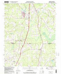
1997 Map of Skippers
USGS Topo · Published 2000About this map
Skippers and the surrounding rural crossroads of southern Virginia and northern North Carolina are documented here in detail. The landscape is defined by its low-lying drainage networks, where Fontaine Creek and Beaverpond Creek wind through heavily wooded tracts. The settlement pattern is largely agricultural, centered on established family and community landmarks such as Turners Crossroads and Brewers Crossroads. Genealogists will find a high density of small community centers, including Zion Ch, Corinth Ch, and Diamond Grove Ch, alongside scattered family burial grounds like Robinson Cem and the Wyche Cem. The geography transitions across the state line into Northampton County, following the course of Jacks Swamp and Caney Swamp as they move toward Corwells Millpond.
Find a feature on this map
29 named features on this map. Tap any name to fly to it.
Don’t see what you’re looking for? This feature index may not catch every label — zoom into the map to look around manually.
Map Details
Editions of this 1997 Skippers Map
This is the sole edition of this map. No revisions or reprints were ever made.
Other maps of this area

1919 · Emporia
USGS Topo · 1:62,500

1919 · Arringdale
USGS Topo · 1:48,000

1920 · Arringdale
USGS Topo · 1:62,500

1942 · Arringdale
USGS Topo · 1:62,500

1942 · Emporia
USGS Topo · 1:62,500

1953 · Norfolk
USGS Topo · 1:250,000

1963 · Skippers
USGS Topo · 1:24,000

1963 · Barley
USGS Topo · 1:24,000

1963 · Emporia
USGS Topo · 1:24,000

1963 · Ante
USGS Topo · 1:24,000