
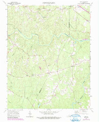
1963 Map of Ante
USGS Topo · Published 1964About this map
The Meherrin River meanders across the Virginia landscape of Brunswick and Greensville counties, anchoring a region defined by small rural settlements and a network of country churches. Small communities like Totaro, Ante, and Radium are connected by secondary roads and the Norfolk Franklin and Danville railroad, which skirts the northern and eastern edges of the quadrangle. The agricultural character of the era is evident in the numerous fine red dashed lines indicating field and fence boundaries throughout the wooded terrain.
Find a feature on this map
28 named features on this map. Tap any name to fly to it.
Don’t see what you’re looking for? This feature index may not catch every label — zoom into the map to look around manually.
Map Details
Editions of this 1963 Ante Map

Other maps of this area

1918 · Lawrenceville
USGS Topo · 1:62,500

1919 · Mc Kenney
USGS Topo · 1:48,000

1919 · White Plains
USGS Topo · 1:48,000

1919 · Emporia
USGS Topo · 1:62,500

1920 · Lawrenceville
USGS Topo · 1:48,000

1920 · White Plains
USGS Topo · 1:62,500

1921 · Mc Kenney
USGS Topo · 1:62,500

1921 · Lawrenceville
USGS Topo · 1:62,500

1942 · Lawrenceville
USGS Topo · 1:62,500

1942 · Emporia
USGS Topo · 1:62,500