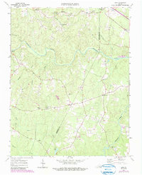
1963 Map of Ante
USGS Topo · Published 1990About this map
Webbs Mill and the surrounding timbered lands of southern Virginia define this rural landscape as it appeared in the mid-20th century. The Meherrin River meanders across the northern portion of the map, serving as a primary drainage for numerous creeks and runs, including Reedy Creek and Brandy Creek. This period reveals a network of small, scattered communities like Ante, Totaro, and Pleasant Shade, where life centered around local landmarks such as Scott Lewis Sch and Rising Star Ch. The map provides significant genealogical value, documenting numerous family-named sites and cemeteries like Pelhams Cem and Powell Cem. Crossing the border from Brunswick into Greensville Co, the terrain transitions into the headwaters of Fountains Creek, illustrating the deep-rooted agricultural and spiritual layout of these neighboring counties.
Find a feature on this map
30 named features on this map. Tap any name to fly to it.
Don’t see what you’re looking for? This feature index may not catch every label — zoom into the map to look around manually.
Map Details
Editions of this 1963 Ante Map


Other maps of this area

1918 · Lawrenceville
USGS Topo · 1:62,500

1919 · Mc Kenney
USGS Topo · 1:48,000

1919 · White Plains
USGS Topo · 1:48,000

1919 · Emporia
USGS Topo · 1:62,500

1920 · Lawrenceville
USGS Topo · 1:48,000

1920 · White Plains
USGS Topo · 1:62,500

1921 · Mc Kenney
USGS Topo · 1:62,500

1921 · Lawrenceville
USGS Topo · 1:62,500

1942 · Lawrenceville
USGS Topo · 1:62,500

1942 · Emporia
USGS Topo · 1:62,500