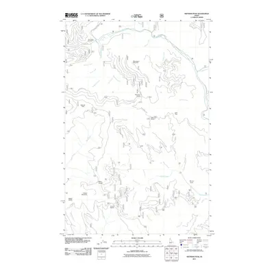
2011 Map of Skitwish Peak
USGS Topo · Published 2011About this map
Little North Fork Coeur d'Alene River winds through the northern reaches of this Idaho landscape, where the naming of Skitwish Peak and Monument Mountain defines a high-elevation network of ridges and drainages. The topography is characterized by a series of prominent passes, including Skookum Saddle, John Saddle, and Marie Saddle, which historically facilitated movement between the numerous creek drainages such as McCauley Creek and Marie Creek. Access to these remote elevations is marked by the presence of Monument L O Rd and Lost Mines Rd, names that reflect the region's history of fire observation and resource extraction. At the northern edge, Honeysuckle Campground serves as a lone point of recreational development along the river, while the surrounding terrain remains dominated by named summits like Copper Mountain and John Peak.
Find a feature on this map
40 named features on this map. Tap any name to fly to it.
Don’t see what you’re looking for? This feature index may not catch every label — zoom into the map to look around manually.
Map Details
Editions of this 2011 Skitwish Peak Map
This is the sole edition of this map. No revisions or reprints were ever made.
Other maps of this area

1903 · Rathdrum
USGS Topo · 1:125,000

1909 · Cataldo
USGS Topo · 1:125,000

1911 · Cataldo
USGS Topo · 1:125,000

1955 · Spokane
USGS Topo · 1:250,000

1957 · Kingston
USGS Topo · 1:62,500

1957 · Lane
USGS Topo · 1:62,500

1958 · Spokane
USGS Topo · 1:250,000

1961 · Lakeview
USGS Topo · 1:62,500

1961 · Athol
USGS Topo · 1:62,500
1981 · Lane
USGS Topo · 1:24,000