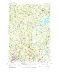
1955 Map of Skowhegan
USGS Topo · Published 1987About this map
The Kennebec River corridor defines the southwestern corner of this mid-1950s survey, anchoring the primary industrial and commercial hub of Skowhegan. The map traces a landscape of transition, where established mill settlements like Malbons Mills and Waltons Mill sit amidst a network of rural schoolhouses and family-named landmarks. Further north, the town of Athens serves as a local center, featuring the Somerset Academy and Mount Rest Cemetery.
Find a feature on this map
142 named features on this map. Tap any name to fly to it.
Don’t see what you’re looking for? This feature index may not catch every label — zoom into the map to look around manually.
Map Details
Editions of this 1955 Skowhegan Map
4 editions found

Other maps of this area

1892 · Waterville
USGS Topo · 1:62,500

1894 · Norridgewock
USGS Topo · 1:62,500

1898 · Norridgewock
USGS Topo · 1:62,500

1903 · Bingham
USGS Topo · 1:62,500

1904 · Anson
USGS Topo · 1:62,500

1905 · Bingham
USGS Topo · 1:62,500

1913 · Skowhegan
USGS Topo · 1:62,500

1926 · Burnham
USGS Topo · 1:62,500

1930 · Pittsfield
USGS Topo · 1:48,000

1932 · Pittsfield
USGS Topo · 1:62,500