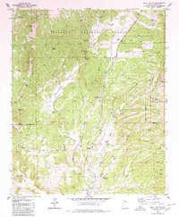
1979 Map of Skull Valley
USGS Topo · Published 1980About this map
Skull Valley serves as a central hub for ranching and transport in this 1970s record of Yavapai County. The landscape is defined by the Atchison Topeka and Santa Fe Railroad winding alongside the Skull Valley Wash, a corridor that supported the local economy through the mid-20th century. Traces of early regional settlement are visible through family-named sites like Contreras Ranch and Old Poley Ranch, while the Skull Valley Cem provides a tangible link for those researching local lineage. To the east, the topography transitions into the Prescott National Forest, where the Gold Star Mine and various prospects suggest a history of mineral exploration in the canyons. The presence of the Quarter Circle J Landing Strip near the town center highlights the area's continued reliance on small-scale aviation and ranching infrastructure.
Find a feature on this map
38 named features on this map. Tap any name to fly to it.
Don’t see what you’re looking for? This feature index may not catch every label — zoom into the map to look around manually.
Map Details
Editions of this 1979 Skull Valley Map
2 editions found
Other maps of this area

1887 · Prescott
USGS Topo · 1:250,000

1892 · Prescott
USGS Topo · 1:250,000

1903 · Congress
USGS Topo · 1:125,000

1904 · Congress
USGS Topo · 1:125,000

1947 · Iron Springs
USGS Topo · 1:62,500

1947 · Kirkland
USGS Topo · 1:62,500

1947 · Sheridan Mountain
USGS Topo · 1:62,500

1948 · Sheridan Mountain
USGS Topo · 1:63,360

1948 · Iron Springs
USGS Topo · 1:63,360

1948 · Kirkland
USGS Topo · 1:63,360