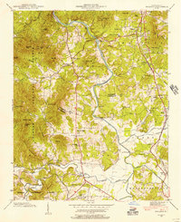
1942 Map of Skyland
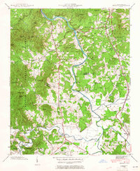
USGS Topo · Published 1956About this map
The French Broad River carves a central path through this 1942 landscape, marking the boundary between Buncombe and Henderson counties. To the east, the Southern railroad corridor anchors established communities like Arden, Fletcher, and Skyland, while the Dixie Highway provides a primary automotive artery through Royal Pines. This era shows a well-developed network of river crossings, including the Long Shoals Bridge, Glenn Bridge, and Fanning Bridge, which linked the agricultural lands of Mills River to the growing residential and commercial hubs near the rail line.
Find a feature on this map
66 named features on this map. Tap any name to fly to it.
Don’t see what you’re looking for? This feature index may not catch every label — zoom into the map to look around manually.
Map Details
Editions of this 1942 Skyland Map
2 editions found
Other maps of this area

1894 · Asheville
USGS Topo · 1:125,000

1900 · Mount Mitchell
USGS Topo · 1:125,000

1901 · Asheville
USGS Topo · 1:125,000

1902 · Mount Mitchell
USGS Topo · 1:125,000

1905 · Pisgah
USGS Topo · 1:125,000

1906 · Pisgah
USGS Topo · 1:125,000

1907 · Saluda
USGS Topo · 1:125,000

1935 · Horse Shoe
USGS Topo · 1:24,000

1935 · Hendersonville
USGS Topo · 1:24,000

1935 · Pisgah Forest
USGS Topo · 1:24,000