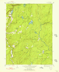
1943 Map of Skytop
USGS Topo · Published 1956About this map
Skytop and the surrounding wilderness of the Pocono Mountain range define this 1943 landscape, characterized by high-elevation lakes and a network of creeks that feed into the Delaware River watershed. This survey captures a transition in land use, where rugged terrain and vast wetlands like High Swamp and Panther Swamp began to support recreational camps and private clubs. Notable among these are Easton Anglers along the Bush Kill and the Hiawatha Club near the southern boundary. The presence of McComas Chapel and localized settlements like Canadensis provides a genealogical anchor for researchers tracing family history in the townships of Barrett and Middle Smithfield. The map reveals the intricate drainage patterns of the region, from the headwaters at Satus Lake to the meandering courses of Brodhead Creek and Dancing Ridge Run, documenting the area before significant mid-century development altered these natural water systems.
Find a feature on this map
58 named features on this map. Tap any name to fly to it.
Don’t see what you’re looking for? This feature index may not catch every label — zoom into the map to look around manually.
Map Details
Editions of this 1943 Skytop Map
4 editions found
Other maps of this area

1919 · Pocono
USGS Topo · 1:62,500

1921 · Pocono
USGS Topo · 1:62,500

1923 · Pocono
USGS Topo · 1:62,500

1924 · Bushkill
USGS Topo · 1:48,000

1928 · Ariel
USGS Topo · 1:62,500

1932 · Ariel
USGS Topo · 1:62,500

1935 · Hawley
USGS Topo · 1:62,500

1938 · Hawley
USGS Topo · 1:62,500

1943 · Bushkill
USGS Topo · 1:62,500

1943 · Pocono
USGS Topo · 1:62,500
Featured Places
- Greene Township, PA
- Porter Township, PA
- Paradise Township, PA
- Middle Smithfield Township, PA
- Cresco, Barrett Township