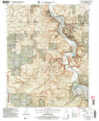
2004 Map of Slabtown Spring
USGS Topo · Published 2006About this map
The Big Piney River meanders through a landscape defined by deep Ozark hollows and federally protected lands at the turn of the 21st century. This area, updated by the Forest Service, highlights the transition from rural settlement to conservation, including the Paddy Creek Wilderness and portions of the Mark Twain National Forest. The map documents the persistent, small-scale footprint of communities like Slabtown, Hazleton, and Roby, while preserving the location of family burial grounds such as Omalley Cem and Merrill Cem.
Find a feature on this map
40 named features on this map. Tap any name to fly to it.
Don’t see what you’re looking for? This feature index may not catch every label — zoom into the map to look around manually.
Map Details
Editions of this 2004 Slabtown Spring Map
This is the sole edition of this map. No revisions or reprints were ever made.
Other maps of this area

1937 · Edgar Springs
USGS Topo · 1:48,000

1941 · Big Piney
USGS Topo · 1:62,500

1941 · Bado
USGS Topo · 1:62,500

1943 · Big Piney
USGS Topo · 1:62,500

1943 · Bado
USGS Topo · 1:62,500

1945 · Edgar Springs
USGS Topo · 1:62,500

1949 · Rolla
USGS Topo · 1:250,000

1951 · Prescott
USGS Topo · 1:24,000

1951 · Raymondville
USGS Topo · 1:62,500

1953 · Rolla
USGS Topo · 1:250,000