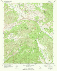
1969 Map of Slack Canyon
USGS Topo · Published 1973About this map
The San Andreas Rift Zone creates a complex system of ridges and valleys across this section of the Monterey and Fresno County border. This 1969 field check captures a landscape defined by its network of springs and canyons, where the Peachtree Valley and Indian Valley serve as primary corridors for movement through the hills. Sparse settlement is anchored by the Slack Canyon Conservation Camp and the small locality of Hewitt.
Find a feature on this map
38 named features on this map. Tap any name to fly to it.
Don’t see what you’re looking for? This feature index may not catch every label — zoom into the map to look around manually.
Map Details
Editions of this 1969 Slack Canyon Map
2 editions found
Other maps of this area

1915 · Priest Valley
USGS Topo · 1:125,000

1919 · San Miguel
USGS Topo · 1:62,500

1919 · Bradley
USGS Topo · 1:62,500

1941 · Priest Valley
USGS Topo · 1:62,500

1941 · San Ardo
USGS Topo · 1:62,500

1941 · Bradley
USGS Topo · 1:62,500

1943 · San Ardo
USGS Topo · 1:62,500

1944 · Priest Valley
USGS Topo · 1:62,500

1947 · San Luis Obispo
USGS Topo · 1:250,000

1947 · San Miguel
USGS Topo · 1:62,500