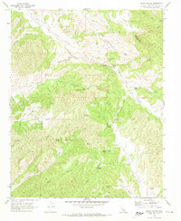
1969 Map of Slack Canyon
USGS Topo · Published 1973About this map
The San Andreas Rift Zone dominates this 1969 topographic study, cutting a distinctive path through the borderlands of Monterey and Fresno counties. The landscape is defined by parallel valleys and steep canyons, with Peachtree Valley and Indian Valley serving as the primary corridors for movement through the region. This is a terrain of scattered water sources and isolated settlements, where survival and travel historically relied on the network of springs like Bitterwater Spring, McMillan Spring, and Splitrock Spring.
Find a feature on this map
40 named features on this map. Tap any name to fly to it.
Don’t see what you’re looking for? This feature index may not catch every label — zoom into the map to look around manually.
Map Details
Editions of this 1969 Slack Canyon Map
2 editions found
Other maps of this area

1915 · Priest Valley
USGS Topo · 1:125,000

1919 · San Miguel
USGS Topo · 1:62,500

1919 · Bradley
USGS Topo · 1:62,500

1941 · Priest Valley
USGS Topo · 1:62,500

1941 · San Ardo
USGS Topo · 1:62,500

1941 · Bradley
USGS Topo · 1:62,500

1943 · San Ardo
USGS Topo · 1:62,500

1944 · Priest Valley
USGS Topo · 1:62,500

1947 · San Luis Obispo
USGS Topo · 1:250,000

1947 · San Miguel
USGS Topo · 1:62,500