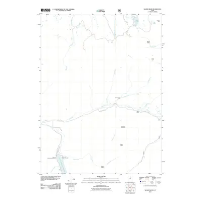
2011 Map of Slader Basin
USGS Topo · Published 2011About this map
The Weber River winds through this high-country landscape, providing the central drainage for a region defined by alpine basins and sharp ridgelines. Water management and recreation are primary features, anchored by the Smith and Morehouse Dam and the sprawling Smith and Morehouse Reservoir at the southern edge. This area, long utilized for seasonal ranching and outdoor activity, includes the Thousand Peaks Ranch and designated camping areas such as the Aspen Grove Campground and the Smith and Morehouse Campground. The terrain is characterized by high-elevation points like Humpy Peak and Windy Ridge, with drainage systems including Middle Fork East Fork Chalk Creek and Red Creek flowing from the north. Local access is marked by E Holiday Park Rd and Quackie Acres Rd, which follow the river valley through Silks Basin and toward the many smaller alpine lakes like Boyer Lake and Blue Lake.
Find a feature on this map
27 named features on this map. Tap any name to fly to it.
Don’t see what you’re looking for? This feature index may not catch every label — zoom into the map to look around manually.
Map Details
Editions of this 2011 Slader Basin Map
This is the sole edition of this map. No revisions or reprints were ever made.
Other maps of this area

1885 · Salt Lake
USGS Topo · 1:250,000

1885 · Uinta
USGS Topo · 1:250,000

1900 · Coalville
USGS Topo · 1:125,000

1901 · Hayden Peak
USGS Topo · 1:125,000

1903 · Hayden Peak
USGS Topo · 1:125,000

1903 · Coalville
USGS Topo · 1:125,000

1954 · Salt Lake City
USGS Topo · 1:250,000

1958 · Salt Lake City
USGS Topo · 1:250,000

1960 · Salt Lake City
USGS Topo · 1:250,000
1967 · Upton
USGS Topo · 1:24,000