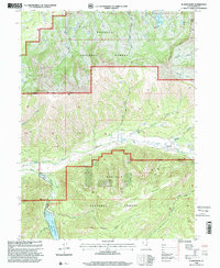
1998 Map of Slader Basin
USGS Topo · Published 2001About this map
The high alpine country of the Wasatch National Forest is defined by sharp ridges and deep drainage basins as they appeared in the late 1990s. This survey centers on the drainage of the Weber River and its numerous tributaries, including Stillman Creek and Larrabee Creek. Significant peaks such as Humpy Peak anchor the northeast, while the massive Slader Basin and Slader Ridge dominate the southern landscape. The presence of the Thousand Peaks Ranch and the Smith and Morehouse Campground near the Smith and Morehouse Reservoir highlights the intersection of private ranching and public recreation in Summit County. The map provides a detailed view of the terrain before later wilderness management changes, marking the boundary between the Evanston Ranger District and the Kamas Ranger District.
Find a feature on this map
33 named features on this map. Tap any name to fly to it.
Don’t see what you’re looking for? This feature index may not catch every label — zoom into the map to look around manually.
Map Details
Editions of this 1998 Slader Basin Map
This is the sole edition of this map. No revisions or reprints were ever made.
Other maps of this area

1885 · Salt Lake
USGS Topo · 1:250,000

1885 · Uinta
USGS Topo · 1:250,000

1900 · Coalville
USGS Topo · 1:125,000

1901 · Hayden Peak
USGS Topo · 1:125,000

1903 · Hayden Peak
USGS Topo · 1:125,000

1903 · Coalville
USGS Topo · 1:125,000

1954 · Salt Lake City
USGS Topo · 1:250,000

1958 · Salt Lake City
USGS Topo · 1:250,000

1960 · Salt Lake City
USGS Topo · 1:250,000
1967 · Upton
USGS Topo · 1:24,000