
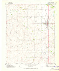
1971 Map of Slapout
USGS Topo · Published 1973About this map
Slapout serves as the focal point of this western Oklahoma landscape, situated at the junction of Highway 270 during the early 1970s. The region is defined by the high plains topography of Bluegrass and the drainage basins of Camp Creek and Clear Creek. The area's mid-century economic character is clearly mapped through a dense network of Gas Wells, underground Pipelines, and a Drill Hole, illustrating the intensity of energy extraction in the Panhandle. Local social history is anchored by the Fairview Ch and Poplar Grove Cem near the border of Beaver and Ellis Counties. The presence of a Roadside Park and a Radio Tower further speaks to the modern infrastructure supporting this rural community as it transitioned through the post-war era.
Find a feature on this map
17 named features on this map. Tap any name to fly to it.
Don’t see what you’re looking for? This feature index may not catch every label — zoom into the map to look around manually.
Map Details
Editions of this 1971 Slapout Map
This is the sole edition of this map. No revisions or reprints were ever made.
Other maps of this area

1954 · Perryton
USGS Topo · 1:250,000

1955 · Woodward
USGS Topo · 1:250,000

1958 · Perryton
USGS Topo · 1:250,000

1958 · Woodward
USGS Topo · 1:250,000

1969 · Shattuck NW
USGS Topo · 1:24,000

1970 · Laverne SW
USGS Topo · 1:24,000

1971 · Logan
USGS Topo · 1:24,000

1971 · Logan NW
USGS Topo · 1:24,000

1971 · Logan NE
USGS Topo · 1:24,000
1971 · Laverne
USGS Topo · 1:24,000