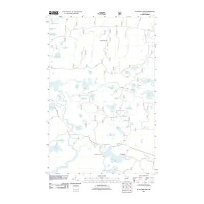
2011 Map of Slate Lake East
USGS Topo · Published 2011About this map
Stony River and the Snake River wind through this heavily forested landscape in Lake County, characterized by a complex network of glacial lakes and northern wetlands. The terrain is defined by low-lying water bodies and the prominent Jack Pine Mountain, while the human footprint is primarily limited to recreational and forestry infrastructure. Established sites like Camp Buckskin and the McDougal Lakes Campground indicate the area's significance for outdoor residency and youth camping.
Find a feature on this map
58 named features on this map. Tap any name to fly to it.
Don’t see what you’re looking for? This feature index may not catch every label — zoom into the map to look around manually.
Map Details
Editions of this 2011 Slate Lake East Map
This is the sole edition of this map. No revisions or reprints were ever made.
Other maps of this area

1954 · Greenwood Lake
USGS Topo · 1:62,500

1954 · Two Harbors
USGS Topo · 1:250,000

1955 · Isabella
USGS Topo · 1:62,500

1957 · Two Harbors
USGS Topo · 1:250,000

1957 · Gabbro Lake
USGS Topo · 1:62,500

1958 · Two Harbors
USGS Topo · 1:250,000

1964 · Two Harbors
USGS Topo · 1:250,000
1981 · Gabbro Lake
USGS Topo · 1:24,000
1981 · Slate Lake West
USGS Topo · 1:24,000
1981 · Bogberry Lake
USGS Topo · 1:24,000