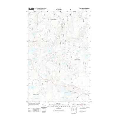
2013 Map of Slate Lake East
USGS Topo · Published 2013About this map
Superior National Forest dominates this northern Minnesota landscape, where the Snake River and Little Isabella River wind through a dense network of glacial lakes and wetlands. The geography is characterized by numerous small bodies of water with evocative names like Chipmunk Lake, Beetle Lake, and Two Deer Lake. Human activity centers on seasonal recreation and timber management, visible through the presence of Camp Buckskin and the McDougal Lakes Campground in the south. The area is traversed by a grid of forest routes, including the prominent east-west Tomahawk Rd and State Hwy 1, which provide access to the high ground of Jack Pine Mountain. These roads and the Stony River drainage define the transport and ecological patterns of this wilderness area in the early 21st century.
Find a feature on this map
54 named features on this map. Tap any name to fly to it.
Don’t see what you’re looking for? This feature index may not catch every label — zoom into the map to look around manually.
Map Details
Editions of this 2013 Slate Lake East Map
This is the sole edition of this map. No revisions or reprints were ever made.
Other maps of this area

1954 · Greenwood Lake
USGS Topo · 1:62,500

1954 · Two Harbors
USGS Topo · 1:250,000

1955 · Isabella
USGS Topo · 1:62,500

1957 · Two Harbors
USGS Topo · 1:250,000

1957 · Gabbro Lake
USGS Topo · 1:62,500

1958 · Two Harbors
USGS Topo · 1:250,000

1964 · Two Harbors
USGS Topo · 1:250,000
1981 · Gabbro Lake
USGS Topo · 1:24,000
1981 · Slate Lake West
USGS Topo · 1:24,000
1981 · Bogberry Lake
USGS Topo · 1:24,000