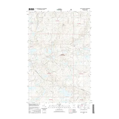
2016 Map of Slate Lake East
USGS Topo · Published 2016About this map
Superior National Forest encompasses this section of Lake County, where a dense network of waterways and timber trails defines the landscape. The Snake River and Stony River meander through the terrain, connecting a vast series of glacial lakes including McDougal Lake, Slate Lake, and the remote Jackpot Lake. The area's character is heavily influenced by forest management and recreation, evidenced by numerous designated routes such as the Stony Spur Trail, Jackpot Trail, and the Stony Spur Summer route. Transportation is anchored by Minnesota Highway 1 in the southern portion, providing access to landmarks like Jack Pine Mtn. The naming of features like Camp Buckskin Road and Eikala Lake Access points to the area's established role in Northwoods outdoor life and seasonal residency.
Find a feature on this map
83 named features on this map. Tap any name to fly to it.
Don’t see what you’re looking for? This feature index may not catch every label — zoom into the map to look around manually.
Map Details
Editions of this 2016 Slate Lake East Map
This is the sole edition of this map. No revisions or reprints were ever made.
Other maps of this area

1954 · Greenwood Lake
USGS Topo · 1:62,500

1954 · Two Harbors
USGS Topo · 1:250,000

1955 · Isabella
USGS Topo · 1:62,500

1957 · Two Harbors
USGS Topo · 1:250,000

1957 · Gabbro Lake
USGS Topo · 1:62,500

1958 · Two Harbors
USGS Topo · 1:250,000

1964 · Two Harbors
USGS Topo · 1:250,000
1981 · Gabbro Lake
USGS Topo · 1:24,000
1981 · Slate Lake West
USGS Topo · 1:24,000
1981 · Bogberry Lake
USGS Topo · 1:24,000