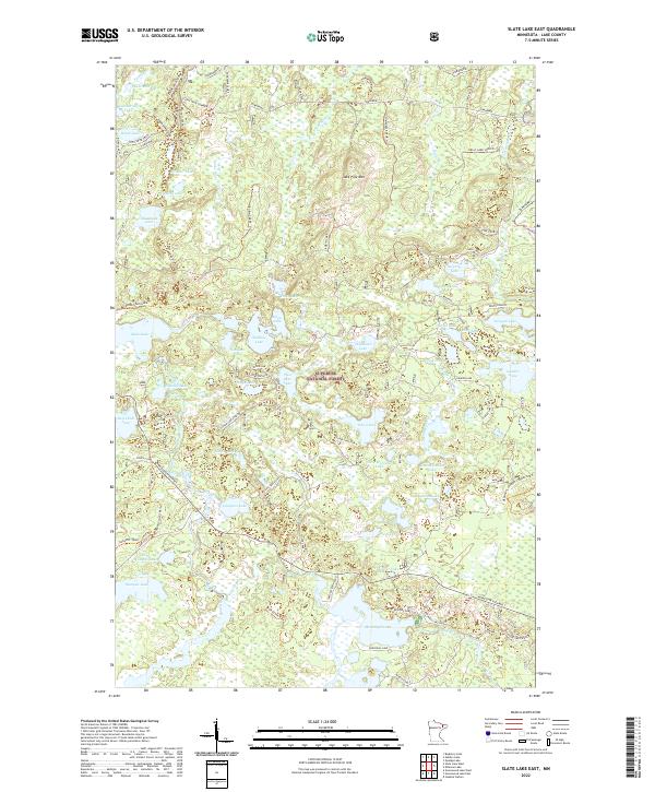
2022 Map of Slate Lake East
USGS Topo · Published 2022About this map
Superior National Forest dominates this northern Minnesota landscape, where a dense network of forest roads and trails provides access to numerous glacial lakes and wetlands. The intricate hydrography of the region is centered on the Stony River and its tributaries, including August Creek and Robin Creek. This terrain is characterized by its numerous named water bodies, ranging from the larger Dunningan Lake and Gunsten Lake to smaller basins like Alsike Lake and Leatherleaf Lake. Recreational and industrial access is traced through a complex system of named routes such as the Stony Spur Trail, Tomahawk, and the Jackpot OHV Trail. Jack Pine Mtn stands as a prominent landmark amidst a wilderness largely defined by its water-and-woods character. Minnesota Highway 1 serves as the primary artery through this remote section of Lake County.
Find a feature on this map
90 named features on this map. Tap any name to fly to it.
Don’t see what you’re looking for? This feature index may not catch every label — zoom into the map to look around manually.
Map Details
Editions of this 2022 Slate Lake East Map
This is the sole edition of this map. No revisions or reprints were ever made.
Other maps of this area

1954 · Greenwood Lake
USGS Topo · 1:62,500

1954 · Two Harbors
USGS Topo · 1:250,000

1955 · Isabella
USGS Topo · 1:62,500

1957 · Two Harbors
USGS Topo · 1:250,000

1957 · Gabbro Lake
USGS Topo · 1:62,500

1958 · Two Harbors
USGS Topo · 1:250,000

1964 · Two Harbors
USGS Topo · 1:250,000
1981 · Gabbro Lake
USGS Topo · 1:24,000
1981 · Slate Lake West
USGS Topo · 1:24,000
1981 · Bogberry Lake
USGS Topo · 1:24,000