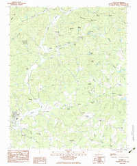
1983 Map of Slater
USGS Topo · Published 1983About this map
The Saluda River and its north fork define the landscape of northern Greenville County, where industrial history meets the foothills of the Blue Ridge. The company town of Slater is anchored by its textile mill infrastructure and local Golf Course, while nearby Marietta sits at a historic crossroads. Along the river banks, recreational and commercial spaces like the Riverside Speedway and Pleasant Ridge State Park appear alongside agricultural rural settlements like Lima and Locust Hill. Evidence of the area's older transportation network is found in the Old Railroad Grade running south of the river. The map also reveals a dense network of local congregations and community centers, including North Greenville Ch, Walnut Grove Ch, and Mush Creek Ch, which serve as vital markers for genealogical research in this Piedmont region.
Find a feature on this map
52 named features on this map. Tap any name to fly to it.
Don’t see what you’re looking for? This feature index may not catch every label — zoom into the map to look around manually.
Map Details
Editions of this 1983 Slater Map
2 editions found
Other maps of this area

1888 · Pickens
USGS Topo · 1:125,000

1894 · Pickens
USGS Topo · 1:125,000

1905 · Pisgah
USGS Topo · 1:125,000

1906 · Pisgah
USGS Topo · 1:125,000

1907 · Saluda
USGS Topo · 1:125,000

1935 · Standingstone Mtn.
USGS Topo · 1:24,000

1935 · Greenville
USGS Topo · 1:48,000

1935 · Zirconia
USGS Topo · 1:24,000

1938 · Greenville
USGS Topo · 1:62,500
1946 · Standingstone Mtn.
USGS Topo · 1:24,000