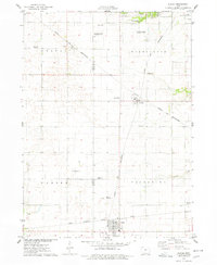
1975 Map of Slater
USGS Topo · Published 1978About this map
Agricultural research and railway hubs define this central Iowa landscape during the mid-1970s. The Iowa State University Experimental Farms occupy significant acreage in the northern section, highlighting the region's academic and scientific ties to farming. Transportation is anchored by the crossing of the Chicago and North Western and the Chicago Milwaukee St Paul and Pacific railroads, which facilitated the growth of towns like Slater and Kelley. Small aviation hubs such as the Erickson Landing Strip and another unnamed Landing Strip near the Boone and Story County line indicate the local importance of private flight. Rural life is anchored by local landmarks like the Bethany Cem and Zumwalt Station Park, while Ballard Creek and Walnut Creek drain the surrounding fields toward the larger river basins beyond this survey's borders.
Find a feature on this map
25 named features on this map. Tap any name to fly to it.
Don’t see what you’re looking for? This feature index may not catch every label — zoom into the map to look around manually.
Map Details
Editions of this 1975 Slater Map
This is the sole edition of this map. No revisions or reprints were ever made.
Other maps of this area

1911 · Madrid
USGS Topo · 1:62,500

1911 · Slater
USGS Topo · 1:62,500

1912 · Ames
USGS Topo · 1:62,500

1913 · Slater
USGS Topo · 1:62,500

1914 · Madrid
USGS Topo · 1:62,500

1914 · Ames
USGS Topo · 1:62,500

1916 · Boone
USGS Topo · 1:62,500

1954 · Waterloo
USGS Topo · 1:250,000

1954 · Des Moines
USGS Topo · 1:250,000

1955 · Waterloo
USGS Topo · 1:250,000