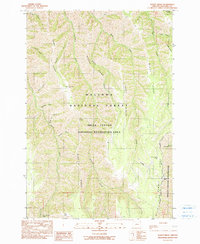
1990 Map of Sleepy Ridge
USGS Topo · Published 1990About this map
Haas Ridge and Sleepy Ridge dominate this corner of northeastern Oregon, defining a landscape of deep drainages and high divides within the Wallowa National Forest. Compiled from early 1980s aerial photography, the map documents a transition in land use, where former livestock sites like the Haas Horse Troughs (Site) persist alongside the designated Hells Canyon Wilderness. Waterways such as Lightning Creek, Medicine Creek, and the curiously named Windy Hell Canyon carve through the terrain, illustrating the complex hydrology of the Hells Canyon National Recreation Area. Higher elevations are marked by distinctive landmarks including Bald Knob, Grassy Knoll, and the high reaches of Summit Ridge. The map's detail provides a record of traditional resource access points and modern recreational boundaries as they stood at the start of the 1990s.
Find a feature on this map
33 named features on this map. Tap any name to fly to it.
Don’t see what you’re looking for? This feature index may not catch every label — zoom into the map to look around manually.
Map Details
Editions of this 1990 Sleepy Ridge Map
This is the sole edition of this map. No revisions or reprints were ever made.
Other maps of this area

1922 · He Devil
USGS Topo · 1:48,000

1954 · Imnaha
USGS Topo · 1:62,500

1954 · Kernan Point
USGS Topo · 1:62,500

1954 · Harl Butte
USGS Topo · 1:62,500

1955 · Grangeville
USGS Topo · 1:250,000

1957 · He Devil
USGS Topo · 1:62,500

1959 · Grangeville
USGS Topo · 1:250,000

1980 · Grangeville
USGS Topo · 1:100,000

1987 · Riggins
USGS Topo · 1:100,000

1990 · Imnaha
USGS Topo · 1:24,000