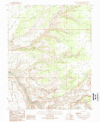
1989 Map of Slickhorn Canyon East
USGS Topo · Published 1989About this map
The San Juan River defines the southwestern edge of this landscape, carving a deep path through the canyonlands of San Juan County. This 1989 provisional survey captures the intersection of several distinct land management areas, including the Glen Canyon National Recreation Area and the Navajo Indian Reservation. The river itself is punctuated by the Government Rapids, a notable feature for river navigation. To the east and west of the drainage, the topography rises into several prominent plateaus, such as Cedar Mesa and Douglas Mesa. Smaller named landmarks like Cowboy Hat and Hat Rock provide localized reference points within the complex drainages of Slickhorn Canyon and Johns Canyon. This map is particularly useful for understanding the isolation and drainage patterns of the high mesas, like Pollys Pasture, in the years following the establishment of the surrounding national recreation area.
Find a feature on this map
16 named features on this map. Tap any name to fly to it.
Don’t see what you’re looking for? This feature index may not catch every label — zoom into the map to look around manually.
Map Details
Editions of this 1989 Slickhorn Canyon East Map
2 editions found
Other maps of this area

1886 · Henry Mountains
USGS Topo · 1:250,000

1886 · Abajo
USGS Topo · 1:250,000

1892 · Abajo
USGS Topo · 1:250,000

1892 · Henry Mountains
USGS Topo · 1:250,000

1893 · Abajo
USGS Topo · 1:250,000

1954 · Clay Hills 1 NW
USGS Topo · 1:24,000

1956 · Escalante
USGS Topo · 1:250,000

1956 · Cortez
USGS Topo · 1:250,000

1958 · Cortez
USGS Topo · 1:250,000

1959 · Cortez
USGS Topo · 1:250,000