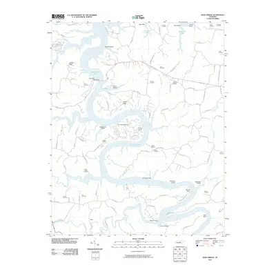
2010 Map of Sligo Bridge
USGS Topo · Published 2010About this map
Center Hill Lake dominates this 2010 landscape, its waters filling the narrow, winding valleys of the Caney Fork River system. The topography is defined by the complex interface of water and land, where prominent landforms like Stillhouse Point and Young Bend reach into the reservoir. This modern survey illustrates how recreation and tourism have integrated with the traditional rural character of the area, evidenced by the presence of Sligo Dock, Pates Ford Dock, and the Four Seasons Marina alongside numerous legacy family cemeteries.
Find a feature on this map
101 named features on this map. Tap any name to fly to it.
Don’t see what you’re looking for? This feature index may not catch every label — zoom into the map to look around manually.
Map Details
Editions of this 2010 Sligo Bridge Map
This is the sole edition of this map. No revisions or reprints were ever made.
Other maps of this area

1893 · Mc Minnville
USGS Topo · 1:125,000

1895 · Mc Minnville
USGS Topo · 1:125,000

1928 · Gordonsville
USGS Topo · 1:62,500

1942 · Statesville
USGS Topo · 1:100,000

1943 · Cookeville
USGS Topo · 1:100,000

1944 · Cookeville
USGS Topo · 1:100,000

1953 · Chattanooga
USGS Topo · 1:250,000
1956 · Burgess Falls
USGS Topo · 1:24,000

1956 · Silver Point
USGS Topo · 1:24,000

1956 · Corbin
USGS Topo · 1:250,000