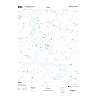
2013 Map of Sligo Bridge
USGS Topo · Published 2013About this map
Center Hill Lake dominates this Tennessee landscape, its winding shoreline carving out numerous peninsulas and deep hollows like Ragland Hollow and Stillhouse Hollow. The crossing at Sligo Bridge serves as a primary link across the water, supported by recreational hubs including Sligo Dock and the Four Seasons Marina. This area is characterized by a mix of long-standing rural settlements such as Peeled Chestnut and Johnsons Chapel, alongside newer lakeside developments like those at Young Bend. Higher elevations like Johnson Ridge and Hopper Ridge define the local topography, while historical traces remain visible at the Indian Mound near Stillhouse Point. Local education and commerce are represented by Hutchins College in the east and the DeKalb County Landfill near the center of the sheet, reflecting a transition between residential recreation and traditional community infrastructure.
Find a feature on this map
164 named features on this map. Tap any name to fly to it.
Don’t see what you’re looking for? This feature index may not catch every label — zoom into the map to look around manually.
Map Details
Editions of this 2013 Sligo Bridge Map
This is the sole edition of this map. No revisions or reprints were ever made.
Other maps of this area

1893 · Mc Minnville
USGS Topo · 1:125,000

1895 · Mc Minnville
USGS Topo · 1:125,000

1928 · Gordonsville
USGS Topo · 1:62,500

1942 · Statesville
USGS Topo · 1:100,000

1943 · Cookeville
USGS Topo · 1:100,000

1944 · Cookeville
USGS Topo · 1:100,000

1953 · Chattanooga
USGS Topo · 1:250,000
1956 · Burgess Falls
USGS Topo · 1:24,000

1956 · Silver Point
USGS Topo · 1:24,000

1956 · Corbin
USGS Topo · 1:250,000