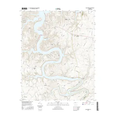
2016 Map of Sligo Bridge
USGS Topo · Published 2016About this map
Center Hill Lake dominates this mid-2010s landscape on the Dekalb Co and White Co border, its winding waters carving deep into the plateau to create complex features like Young Bend and Adcock Bend. This survey illustrates the modern topography of a region defined by its rugged drainages, where numerous "hollows" like Quarry Hollow and Stillhouse Hollow break the high ground. Small rural settlements and crossroads remain focal points for local history, including the communities of Peeled Chestnut and Johnsons Chapel.
Find a feature on this map
65 named features on this map. Tap any name to fly to it.
Don’t see what you’re looking for? This feature index may not catch every label — zoom into the map to look around manually.
Map Details
Editions of this 2016 Sligo Bridge Map
This is the sole edition of this map. No revisions or reprints were ever made.
Other maps of this area

1893 · Mc Minnville
USGS Topo · 1:125,000

1895 · Mc Minnville
USGS Topo · 1:125,000

1928 · Gordonsville
USGS Topo · 1:62,500

1942 · Statesville
USGS Topo · 1:100,000

1943 · Cookeville
USGS Topo · 1:100,000

1944 · Cookeville
USGS Topo · 1:100,000

1953 · Chattanooga
USGS Topo · 1:250,000
1956 · Burgess Falls
USGS Topo · 1:24,000

1956 · Silver Point
USGS Topo · 1:24,000

1956 · Corbin
USGS Topo · 1:250,000