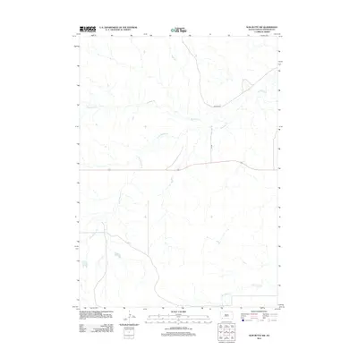
2012 Map of Slim Butte NW
USGS Topo · Published 2012About this map
The hydrological network of Blacktail Cr and its tributary S Br Blacktail Cr defines this territory within the Pine Ridge Reservation. This portion of the landscape, mapped in 2012, is characterized by its drainage basins and the intermittent flow of Slim Butte Cr to the south. Transportation is primarily facilitated by Bureau of Indian Affairs routes, including the primary corridor of BIA Road 52. These roads follow the natural contours of the terrain, providing essential connectivity across the grasslands and drainage divides of Shannon County. The map provides a clear picture of the modern rural infrastructure and water management features, including several small stock ponds and reservoirs essential for land use in this part of South Dakota.
Find a feature on this map
5 named features on this map. Tap any name to fly to it.
Don’t see what you’re looking for? This feature index may not catch every label — zoom into the map to look around manually.
Map Details
Editions of this 2012 Slim Butte NW Map
This is the sole edition of this map. No revisions or reprints were ever made.
Other maps of this area

1896 · Oelrichs
USGS Topo · 1:125,000

1900 · Oelrichs
USGS Topo · 1:125,000

1955 · Hot Springs
USGS Topo · 1:250,000

1967 · Slim Butte SW
USGS Topo · 1:24,000

1967 · Slim Butte NW
USGS Topo · 1:24,000

1967 · Slim Butte NE
USGS Topo · 1:24,000

1967 · Slim Butte
USGS Topo · 1:24,000

1967 · Willow Creek SW
USGS Topo · 1:24,000

1967 · Willow Creek
USGS Topo · 1:24,000
1982 · Heinne Creek
USGS Topo · 1:25,000