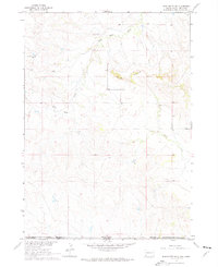
1967 Map of Slim Butte SW
USGS Topo · Published 1976About this map
The Pine Ridge Indian Reservation Boundary stretches across the southern reaches of this landscape, defining the jurisdictional edge where Shannon Co and Dawes Co meet the Nebraska state line. This mid-century topographical study reveals a terrain of dramatic relief dominated by the geological prominence of Slim Butte. The drainage patterns are clearly defined by the winding course of Slim Butte Creek to the north and Alkali Creek to the south, highlighting the natural water sources that have long shaped land use in this arid region. Surveyed during the 1960s, the map also meticulously records ranching infrastructure through fine red dashed lines indicating fence and field lines, offering a precise look at the rural land management and agricultural boundaries of the era.
Find a feature on this map
5 named features on this map. Tap any name to fly to it.
Don’t see what you’re looking for? This feature index may not catch every label — zoom into the map to look around manually.
Map Details
Editions of this 1967 Slim Butte SW Map
2 editions found
Other maps of this area

1896 · Oelrichs
USGS Topo · 1:125,000

1900 · Oelrichs
USGS Topo · 1:125,000

1955 · Hot Springs
USGS Topo · 1:250,000

1955 · Alliance
USGS Topo · 1:250,000

1957 · Alliance
USGS Topo · 1:250,000

1958 · Alliance
USGS Topo · 1:250,000

1967 · Slim Butte SW
USGS Topo · 1:24,000

1967 · Slim Butte NW
USGS Topo · 1:24,000

1967 · Slim Butte NE
USGS Topo · 1:24,000

1967 · Slim Butte
USGS Topo · 1:24,000