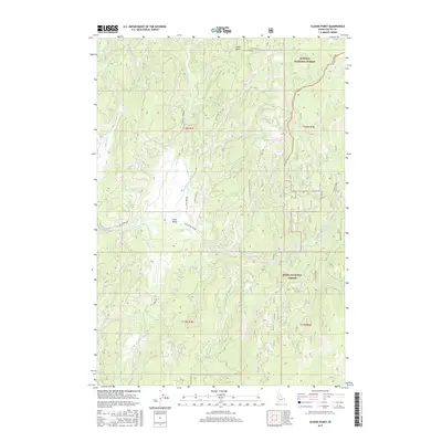
2017 Map of Sloans Point
USGS Topo · Published 2017About this map
Gold Fork Hot Spring marks a significant thermal landmark in this portion of Valley County, where the high-elevation terrain serves as a critical watershed for the Gold Fork River. The landscape is defined by the boundary between the Payette National Forest and Boise National Forest, reflecting the managed wilderness character of the region. A network of forest roads and trails, such as the Foolhen Ridge Fire Trl and Sloans Point Rd, provide access through the timbered ridges surrounding Sloans Point. The confluence of several drainage systems, including the N Fork Gold Fork River and S Fork Gold Fork River, illustrates the complex hydrologic pattern that shapes Little Valley and its surrounding mountain slopes.
Find a feature on this map
29 named features on this map. Tap any name to fly to it.
Don’t see what you’re looking for? This feature index may not catch every label — zoom into the map to look around manually.
Map Details
Editions of this 2017 Sloans Point Map
This is the sole edition of this map. No revisions or reprints were ever made.
Other maps of this area

1911 · Meadows
USGS Topo · 1:125,000

1954 · Gold Fork
USGS Topo · 1:62,500

1954 · Cascade
USGS Topo · 1:62,500

1955 · Baker
USGS Topo · 1:250,000

1957 · Challis
USGS Topo · 1:250,000

1959 · Baker
USGS Topo · 1:250,000

1960 · Challis
USGS Topo · 1:250,000

1963 · Challis
USGS Topo · 1:250,000

1973 · Blackmare
USGS Topo · 1:24,000
1973 · Paddy Flat
USGS Topo · 1:24,000