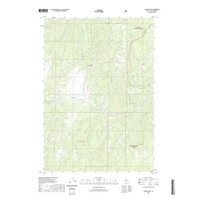
2020 Map of Sloans Point
USGS Topo · Published 2020About this map
Little Valley sits at the heart of this high-elevation terrain where the northern and southern Idaho forests meet. The hydrology is dominated by the Gold Fork River and its numerous tributaries, including Rapid Cr and French Cr. A significant cultural and geological landmark, the Gold Fork Hot Spring is located near the riverbanks, reflecting the geothermal character of the region. The map documents the boundary between the Payette National Forest and the Boise National Forest, a division that has shaped land use and conservation in Valley County for over a century. Transportation into this backcountry relies on a network of unpaved routes such as Sloans Point Rd and specialized paths like the Foolhen Ridge Fire Tr, which provides access to the heights of Sloans Point.
Find a feature on this map
25 named features on this map. Tap any name to fly to it.
Don’t see what you’re looking for? This feature index may not catch every label — zoom into the map to look around manually.
Map Details
Editions of this 2020 Sloans Point Map
This is the sole edition of this map. No revisions or reprints were ever made.
Other maps of this area

1911 · Meadows
USGS Topo · 1:125,000

1954 · Gold Fork
USGS Topo · 1:62,500

1954 · Cascade
USGS Topo · 1:62,500

1955 · Baker
USGS Topo · 1:250,000

1957 · Challis
USGS Topo · 1:250,000

1959 · Baker
USGS Topo · 1:250,000

1960 · Challis
USGS Topo · 1:250,000

1963 · Challis
USGS Topo · 1:250,000

1973 · Blackmare
USGS Topo · 1:24,000
1973 · Paddy Flat
USGS Topo · 1:24,000