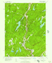
1955 Map of Sloatsburg
USGS Topo · Published 1957About this map
The Ramapo River corridor serves as the primary artery for transport and settlement in this mid-century landscape, carrying the Erie RR, the Thruway, and the Turnpike through the valley. This concentration of infrastructure contrasts sharply with the expansive wild lands of Harriman State Park and Palisades Interstate Park, which dominate the surrounding ridges. The map reveals the internal geography of Tuxedo Park, showing its private roads, the Tuxedo Park Sch, and local landmarks like We-Wah Lake.
Find a feature on this map
93 named features on this map. Tap any name to fly to it.
Don’t see what you’re looking for? This feature index may not catch every label — zoom into the map to look around manually.
Map Details
Editions of this 1955 Sloatsburg Map
2 editions found

Other maps of this area

1891 · Greenwood Lake
USGS Topo · 1:62,500

1891 · Ramapo
USGS Topo · 1:62,500

1893 · Greenwood Lake
USGS Topo · 1:62,500

1893 · Ramapo
USGS Topo · 1:62,500

1902 · Schunemunk
USGS Topo · 1:62,500

1903 · Greenwood Lake
USGS Topo · 1:62,500

1906 · Goshen
USGS Topo · 1:62,500

1908 · Goshen
USGS Topo · 1:62,500

1910 · Ramapo
USGS Topo · 1:62,500

1910 · Greenwood Lake
USGS Topo · 1:62,500