
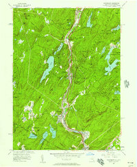
1955 Map of Sloatsburg
USGS Topo · Published 1961About this map
Tuxedo Park and Sloatsburg serve as the primary hubs in this mid-century topographic portrait of the Ramapo Valley, where transportation and topography dictate the region's character. The newly constructed New York State Thruway and the Erie RR run parallel through the narrow valley floor, creating a dense corridor of infrastructure alongside the Ramapo River. This development contrasts sharply with the protected lands of Harriman State Park to the east, which is defined by an extensive trail network including the Victory Trail and Suffern-Bear Mountain Trail. Institutional landmarks are prominent in the southern reaches, notably the St Marys Villa Academy, St Joseph Home for Aged, and Shelton College near the border with Ringwood. The map also captures the recreational geography of the era, from the Tuxedo Park Golf Course to scouting grounds at Spruce Pond Camp (BSA).
Find a feature on this map
91 named features on this map. Tap any name to fly to it.
Don’t see what you’re looking for? This feature index may not catch every label — zoom into the map to look around manually.
Map Details
Editions of this 1955 Sloatsburg Map
2 editions found
Other maps of this area

1891 · Greenwood Lake
USGS Topo · 1:62,500

1891 · Ramapo
USGS Topo · 1:62,500

1893 · Greenwood Lake
USGS Topo · 1:62,500

1893 · Ramapo
USGS Topo · 1:62,500

1902 · Schunemunk
USGS Topo · 1:62,500

1903 · Greenwood Lake
USGS Topo · 1:62,500

1906 · Goshen
USGS Topo · 1:62,500

1908 · Goshen
USGS Topo · 1:62,500

1910 · Ramapo
USGS Topo · 1:62,500

1910 · Greenwood Lake
USGS Topo · 1:62,500