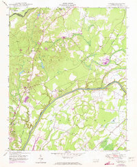
1950 Map of Slocomb
USGS Topo · Published 1973About this map
The Cape Fear River serves as the central artery for this mid-century landscape on the border of Harnett and Cumberland counties. The settlement of Slocomb is positioned near the river banks, showing a rural community tied to the local rail and water networks. The presence of multiple congregations, including Palestine Church, Zion Church, and Cedar Falls Church, along with the Long Hill School, indicates a well-established social fabric in the Carvers Creek and Eastover regions.
Find a feature on this map
20 named features on this map. Tap any name to fly to it.
Don’t see what you’re looking for? This feature index may not catch every label — zoom into the map to look around manually.
Map Details
Editions of this 1950 Slocomb Map
2 editions found
Other maps of this area

1948 · Fayetteville
USGS Topo · 1:62,500

1948 · Slocomb
USGS Topo · 1:24,000

1949 · Vander
USGS Topo · 1:24,000

1950 · Fayetteville
USGS Topo · 1:24,000

1950 · Manchester
USGS Topo · 1:24,000

1950 · Slocomb
USGS Topo · 1:24,000

1953 · Raleigh
USGS Topo · 1:250,000

1954 · Raleigh
USGS Topo · 1:250,000

1956 · Anderson Creek
USGS Topo · 1:24,000

1956 · Bunnlevel
USGS Topo · 1:24,000