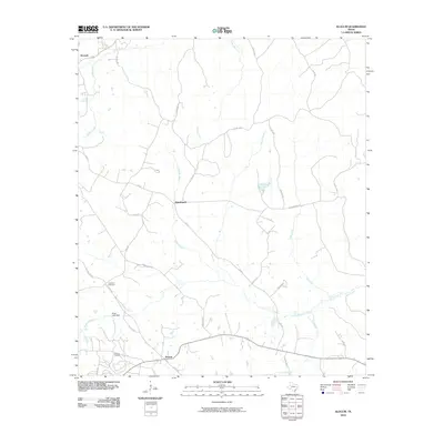
2010 Map of Slocum
USGS Topo · Published 2010About this map
Slocum serves as a primary hub in this portion of Anderson County, characterized by a transition from local agricultural plots to industrial energy extraction. The Slocum Oil Field south of town indicates the long-standing importance of petroleum to the local economy. To the north, the community of Alderbranch sits near the headwaters of Alder Branch, while the settlement of Kossuth occupies the northwest corner of the sheet. The landscape is deeply carved by a network of drainage systems including Snake Creek, Stills Creek, and Ioni Creek. Cultural landmarks such as Crawford Cemetery and the engineering of Mays Lake Dam reflect the established residency and land management of the early 21st century. The road network, featuring routes like Old Boston Rd and Union Hope Rd, connects these dispersed settlements across the creek-bottom terrain.
Find a feature on this map
36 named features on this map. Tap any name to fly to it.
Don’t see what you’re looking for? This feature index may not catch every label — zoom into the map to look around manually.
Map Details
Editions of this 2010 Slocum Map
This is the sole edition of this map. No revisions or reprints were ever made.
Other maps of this area

1949 · Palestine
USGS Topo · 1:62,500

1950 · Palestine
USGS Topo · 1:62,500

1951 · Elkhart
USGS Topo · 1:62,500

1951 · Jacksonville
USGS Topo · 1:62,500

1952 · Slocum
USGS Topo · 1:62,500

1953 · Palestine
USGS Topo · 1:250,000

1957 · Palestine
USGS Topo · 1:250,000

1981 · Palestine
USGS Topo · 1:100,000
1982 · Maydelle
USGS Topo · 1:24,000
1982 · Percilla
USGS Topo · 1:24,000