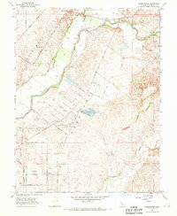
1968 Map of Sloughhouse
USGS Topo · Published 1970About this map
The Cosumnes River corridor dominates this Sacramento County landscape, where the legacy of early land grants is still visible in the Grant Line Road Boundary and the borders of the Mochumne Grant and Cosumne Grant. Agricultural life in the late 1960s is evidenced by a dense network of fruit-named thoroughfares such as Peach Lane, Pear Lane, and Orange Road. Community hubs like the Alta Mesa Community Hall and local institutions such as Rhoades School and Dillard Sch anchor the rural settlements of Sloughhouse and Cosumne. Notable industrial and recreational features are scattered across the terrain, including a Fish Hatchery, an Alta Mesa Gun Club, and a prominent Historical Monument. To the east, the environmental impact of earlier resource extraction is clearly marked by extensive Dredge Tailings and a Gravel Pit near the river's edge.
Find a feature on this map
47 named features on this map. Tap any name to fly to it.
Don’t see what you’re looking for? This feature index may not catch every label — zoom into the map to look around manually.
Map Details
Editions of this 1968 Sloughhouse Map
4 editions found
Other maps of this area

1891 · Sacramento
USGS Topo · 1:125,000

1892 · Sacramento
USGS Topo · 1:125,000

1893 · Sacramento
USGS Topo · 1:125,000

1894 · Lodi
USGS Topo · 1:125,000

1902 · Fairoaks
USGS Topo · 1:62,500

1908 · Buffalo Creek
USGS Topo · 1:31,680

1909 · Elk Grove
USGS Topo · 1:31,680

1909 · Carbondale
USGS Topo · 1:31,680

1909 · Clay
USGS Topo · 1:31,680

1909 · Cosumnes
USGS Topo · 1:31,680