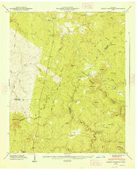
1947 Map of Smartt Mountain
USGS Topo · Published 1948About this map
Cumberland Plateau terrain dominates this 1946 field examination, where the high tableland is deeply incised by the drainage of Piney Creek and Big Brush Creek. The survey captures the rural character of the border between Van Buren, Bledsoe, and Sequatchie Counties, where development followed the narrow valleys and ridges. Local life is anchored by landmarks like Bellview Ch and family burial grounds including Miller Cem and Walling Cem. Of particular interest to topographic historians is the complex drainage pattern where the Tennessee Valley and Robin Ridge Divide meet, creating significant features such as the Whiteoak Swamps and the prominent Jordan Rock House. The map shows a landscape defined by names like Smartt Mtn and Hitchcox Mtn, reflecting the early families who settled these highlands.
Find a feature on this map
73 named features on this map. Tap any name to fly to it.
Don’t see what you’re looking for? This feature index may not catch every label — zoom into the map to look around manually.
Map Details
Editions of this 1947 Smartt Mountain Map
This is the sole edition of this map. No revisions or reprints were ever made.
Other maps of this area

1888 · Chattanooga
USGS Topo · 1:125,000

1892 · Pikeville
USGS Topo · 1:125,000

1893 · Mc Minnville
USGS Topo · 1:125,000

1893 · Chattanooga
USGS Topo · 1:125,000

1895 · Mc Minnville
USGS Topo · 1:125,000

1895 · Sewanee
USGS Topo · 1:125,000

1895 · Pikeville
USGS Topo · 1:125,000

1935 · Brockdell
USGS Topo · 1:24,000

1935 · Mount Airy
USGS Topo · 1:24,000

1935 · Smart Mountain
USGS Topo · 1:24,000