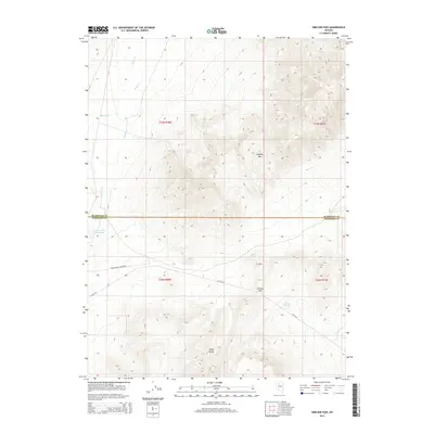
2014 Map of Smelser Pass
USGS Topo · Published 2014About this map
Smelser Pass serves as a critical point of navigation through the high desert terrain of the Tobin Range, marking the boundary between Humboldt and Pershing counties in northern Nevada. The landscape is defined by the elevation of Buffalo Mtn, which dominates the northern half of the region, while the seasonal hydrology of Wilson Cr and Ragan Cr drains the slopes toward the valley floor. Rare water sources in this arid environment are identified at Pumpernickel Reservoir and Summit Spring, providing essential landmarks for ranching and travel. Development is sparse, primarily consisting of the rugged Sheep Ranch Canyon Rd and the NV-93-Alt route, reflecting the area's continued reliance on a few established mountain crossings and water points for transit through the Great Basin.
Find a feature on this map
14 named features on this map. Tap any name to fly to it.
Don’t see what you’re looking for? This feature index may not catch every label — zoom into the map to look around manually.
Map Details
Editions of this 2014 Smelser Pass Map
This is the sole edition of this map. No revisions or reprints were ever made.
Other maps of this area

1932 · Sonoma Range
USGS Topo · 1:250,000

1939 · Sonoma Range
USGS Topo · 1:250,000

1955 · Winnemucca
USGS Topo · 1:250,000

1958 · Winnemucca
USGS Topo · 1:250,000

1958 · Winnemucca
USGS Topo · 1:62,500

1961 · Leach Hot Springs
USGS Topo · 1:62,500

1962 · Winnemucca
USGS Topo · 1:250,000

1965 · Goldrun Creek
USGS Topo · 1:24,000

1965 · Edna Mountain
USGS Topo · 1:62,500
1965 · Brooks Spring
USGS Topo · 1:24,000