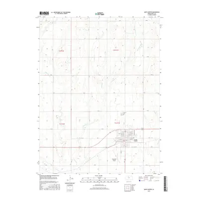
2015 Map of Smith Center
USGS Topo · Published 2015About this map
Smith Center serves as the hub of this Smith County landscape, where the grid of the town meets the sprawling agricultural sections of north-central Kansas. The community is defined by a traditional street layout including W Kansas Ave and the honorific Roger Barta Way, while the Smith Center Municipal Airport to the south facilitates regional connectivity. Surrounding the town, the land is etched by a complex drainage system featuring Middle Beaver Cr, E Beaver Cr, and Troublesome Cr, illustrating the vital role of water management in this prairie environment. This modern survey captures the enduring rural character of the region, anchored by historical landmarks like the Fairview Cem north of the city limits, while highlighting the systematic organization of the countryside through a network of numbered section roads such as 140 RD and 170 RD.
Find a feature on this map
35 named features on this map. Tap any name to fly to it.
Don’t see what you’re looking for? This feature index may not catch every label — zoom into the map to look around manually.
Map Details
Editions of this 2015 Smith Center Map
This is the sole edition of this map. No revisions or reprints were ever made.
Other maps of this area

1893 · Smith Center
USGS Topo · 1:125,000

1955 · Beloit
USGS Topo · 1:250,000

1959 · Beloit
USGS Topo · 1:250,000

1973 · Athol
USGS Topo · 1:24,000
1973 · Cora
USGS Topo · 1:24,000
1973 · Reamsville
USGS Topo · 1:24,000
1973 · Cedar
USGS Topo · 1:24,000
1973 · Bachelors Run
USGS Topo · 1:24,000
1973 · Smith Center
USGS Topo · 1:24,000
1973 · Portis NW
USGS Topo · 1:24,000