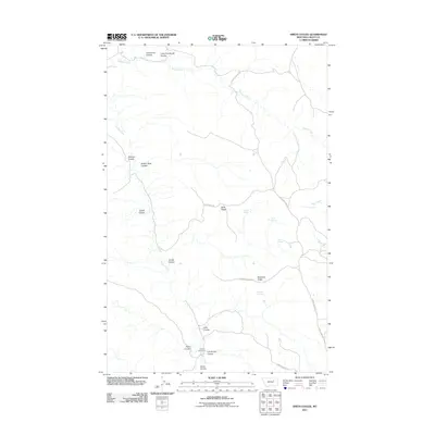
2011 Map of Smith Coulee
USGS Topo · Published 2011About this map
Etchart Cow Camp sits near the southern boundary of this Valley County landscape, a rare named point of habitation in a region defined by its complex drainage network. The topography is dominated by deep seasonal channels and high divides, notably Barth Ridge and Robinson Ridge, which separate the various coulees feeding into Square Creek and Timber Creek.
Find a feature on this map
26 named features on this map. Tap any name to fly to it.
Don’t see what you’re looking for? This feature index may not catch every label — zoom into the map to look around manually.
Map Details
Editions of this 2011 Smith Coulee Map
This is the sole edition of this map. No revisions or reprints were ever made.
Other maps of this area

1954 · Jordan
USGS Topo · 1:250,000

1956 · Jordan
USGS Topo · 1:250,000

1958 · Jordan
USGS Topo · 1:250,000

1964 · Jordan
USGS Topo · 1:250,000

1971 · Wolfe Coulee
USGS Topo · 1:24,000

1971 · Wagon Coulee
USGS Topo · 1:24,000
1971 · Swede Ridge
USGS Topo · 1:24,000

1973 · Triple Crossing Reservoir West
USGS Topo · 1:24,000

1973 · Niles Coulee
USGS Topo · 1:24,000
1973 · Gibson Coulee
USGS Topo · 1:24,000