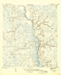
1945 Map of Smith Creek
USGS Topo · Published 1945About this map
The Ochlockonee River forms the central spine of this landscape, carving a winding path through the dense wetlands and timberlands of the Apalachicola National Forest. This 1945 survey reveals an economy and way of life deeply tied to the river, evidenced by a series of specialized river access points including Blazed Pine Landing, Upper Langston Landing, and Big River Landing. These landings, along with the presence of East Camp and Poplar Camp, suggest the active maritime and logging operations of the mid-1940s. Away from the banks, the community centers around the Smith Creek Sch and Mt Elon Ch, while the Jewel Fire Tower stands watch over a complex network of bays and branches such as Tin Top Bay and Tiger Creek. The map meticulously details the transition between Liberty and Wakulla counties, capturing the intricate hydrology of backwater lakes like Frog Lake and X-L Lake.
Find a feature on this map
44 named features on this map. Tap any name to fly to it.
Don’t see what you’re looking for? This feature index may not catch every label — zoom into the map to look around manually.
Map Details
Editions of this 1945 Smith Creek Map
4 editions found

Other maps of this area

1943 · Lake Talquin
USGS Topo · 1:62,500

1944 · Queens Bay
USGS Topo · 1:24,000

1945 · Thousand Yard Bay
USGS Topo · 1:31,680

1945 · Smith Creek
USGS Topo · 1:31,680

1945 · Bradwell Bay
USGS Topo · 1:31,680

1945 · Sanborn
USGS Topo · 1:31,680

1945 · Telogia
USGS Topo · 1:24,000

1946 · Queens Bay
USGS Topo · 1:31,680

1946 · Telogia
USGS Topo · 1:31,680

1946 · Owens Bridge
USGS Topo · 1:31,680