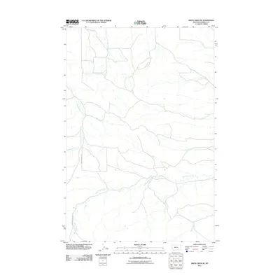
2011 Map of Smith Creek NE
USGS Topo · Published 2011About this map
West Rosebud Creek meanders through this portion of Rosebud County, establishing the primary drainage pattern for an area defined by its riparian corridors and rural road network. This early 21st-century survey by the U. S. Geological Survey illustrates a landscape where transportation follows the natural topography, notably along West Rosebud Creek Rd and Slaughter House Rd. The hydrology is further defined by Slaughterhouse Creek and the headwaters of West Vance Creek. The map provides a detailed view of the land division and the sparse settlement patterns typical of this Montana region, where access is dictated by these established creek-side routes.
Find a feature on this map
5 named features on this map. Tap any name to fly to it.
Don’t see what you’re looking for? This feature index may not catch every label — zoom into the map to look around manually.
Map Details
Editions of this 2011 Smith Creek NE Map
This is the sole edition of this map. No revisions or reprints were ever made.
Other maps of this area

1954 · Forsyth
USGS Topo · 1:250,000

1957 · Forsyth
USGS Topo · 1:250,000

1958 · Forsyth
USGS Topo · 1:250,000

1968 · Orinoco
USGS Topo · 1:24,000

1968 · Rosebud
USGS Topo · 1:24,000

1968 · Forsyth
USGS Topo · 1:24,000

1971 · Smith Creek NE
USGS Topo · 1:24,000
1971 · Smith Creek
USGS Topo · 1:24,000
1971 · Mc Kerlich Creek
USGS Topo · 1:24,000
1971 · Rosebud Buttes
USGS Topo · 1:24,000