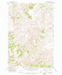
1971 Map of Smith Creek
USGS Topo · Published 1974About this map
Forsyth Country Club marks the northwestern corner of this Rosebud County landscape, representing a recreational outpost on the edge of the more industrial and agricultural terrain. The topography is dominated by the winding path of Smith Creek and its tributary, Slaughterhouse Prong, which cut through the high plains of eastern Montana. Infrastructure of the early 1970s is evident in the multiple segments of Pipeline that traverse the hills, alongside evidence of local resource extraction at a Gravel Pit. The presence of several Stock Dam features and remote Well sites highlights the area's reliance on managed water sources for ranching and land use in this semi-arid environment.
Find a feature on this map
9 named features on this map. Tap any name to fly to it.
Don’t see what you’re looking for? This feature index may not catch every label — zoom into the map to look around manually.
Map Details
Editions of this 1971 Smith Creek Map
This is the sole edition of this map. No revisions or reprints were ever made.
Other maps of this area

1954 · Forsyth
USGS Topo · 1:250,000

1957 · Forsyth
USGS Topo · 1:250,000

1958 · Forsyth
USGS Topo · 1:250,000

1968 · Orinoco
USGS Topo · 1:24,000

1968 · Nichols
USGS Topo · 1:24,000

1968 · Forsyth
USGS Topo · 1:24,000

1971 · Griffin Coulee NE
USGS Topo · 1:24,000

1971 · Smith Creek NE
USGS Topo · 1:24,000
1971 · Mc Kerlich Creek
USGS Topo · 1:24,000
1971 · Sheep Creek Camp
USGS Topo · 1:24,000