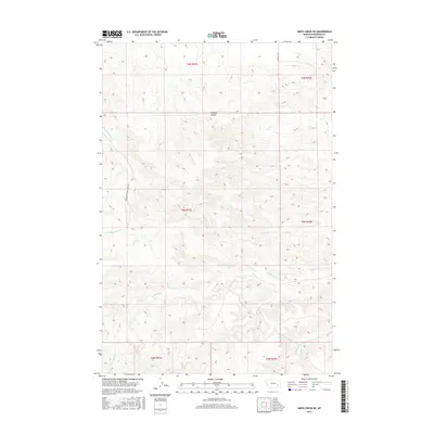
2017 Map of Smith Creek NE
USGS Topo · Published 2017About this map
Wildcat Coulee defines the drainage patterns of this Rosebud County landscape, where the high plains of eastern Montana are etched by seasonal waterways. The terrain is structured by the Public Land Survey System, with the map covering portions of t6n r41e, t6n r42e, and surrounding townships. This 2017 survey shows a land shaped by cattle ranching and sparse infrastructure, where travel is dictated by routes like Slaughterhouse Creek Rd and Wildcat Rd. Water sources are critical but intermittent, including the winding paths of W Rosebud Cr, Slaughterhouse Cr, and W Vance Cr. The density of contour lines illustrates the sharp breaks and draws common to this region, providing a clear record of the area's natural topography and land divisions.
Find a feature on this map
12 named features on this map. Tap any name to fly to it.
Don’t see what you’re looking for? This feature index may not catch every label — zoom into the map to look around manually.
Map Details
Editions of this 2017 Smith Creek NE Map
This is the sole edition of this map. No revisions or reprints were ever made.
Other maps of this area

1954 · Forsyth
USGS Topo · 1:250,000

1957 · Forsyth
USGS Topo · 1:250,000

1958 · Forsyth
USGS Topo · 1:250,000

1968 · Orinoco
USGS Topo · 1:24,000

1968 · Rosebud
USGS Topo · 1:24,000

1968 · Forsyth
USGS Topo · 1:24,000

1971 · Smith Creek NE
USGS Topo · 1:24,000
1971 · Smith Creek
USGS Topo · 1:24,000
1971 · Mc Kerlich Creek
USGS Topo · 1:24,000
1971 · Rosebud Buttes
USGS Topo · 1:24,000