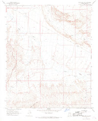
1967 Map of Smith Peak NW
USGS Topo · Published 1969About this map
Date Creek and Bullard Wash carve a network of drainage patterns across this desert landscape, where water management is the primary evidence of human presence in the late 1960s. The southern edge of the sheet is defined by the rising elevations of the Little Buckskin Mts, while the remainder of the terrain is a steady alluvial slope toward the northwest. Isolated infrastructure like East Well, Webber Well, and a lonely Corral indicate the ranching history of the region. Transportation is limited to the prominent Alamo Road and various rugged tracks, including a designated Jeep Trail, that traverse the brush. Several Borrow Pits near the roadway suggest localized material extraction for road maintenance during this period of the mid-20th century.
Find a feature on this map
10 named features on this map. Tap any name to fly to it.
Don’t see what you’re looking for? This feature index may not catch every label — zoom into the map to look around manually.
Map Details
Editions of this 1967 Smith Peak NW Map
2 editions found
Other maps of this area

1923 · Signal
USGS Topo · 1:250,000

1942 · Signal
USGS Topo · 1:250,000

1950 · Prescott
USGS Topo · 1:250,000

1954 · Prescott
USGS Topo · 1:250,000

1958 · Prescott
USGS Topo · 1:250,000

1959 · Prescott
USGS Topo · 1:250,000

1960 · Prescott
USGS Topo · 1:250,000

1965 · Prescott
USGS Topo · 1:250,000

1966 · Ives Peak
USGS Topo · 1:62,500

1966 · Artillery Peak
USGS Topo · 1:62,500