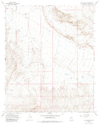
1967 Map of Smith Peak NW
USGS Topo · Published 1985About this map
Cabal sits along the northern reaches of this arid landscape, a region defined by seasonal drainages and isolated desert infrastructure in the late 1960s. The terrain transitions from the low-lying Bullard Wash and Date Creek in the north toward the rising elevations of the Little Buckskin Mts in the south. The map documents a sparsely settled area where life centered on scattered water sources like East Well and Webber Well, which were critical for ranching operations indicated by the presence of a Corral near the wash.
Find a feature on this map
13 named features on this map. Tap any name to fly to it.
Don’t see what you’re looking for? This feature index may not catch every label — zoom into the map to look around manually.
Map Details
Editions of this 1967 Smith Peak NW Map
2 editions found
Other maps of this area

1923 · Signal
USGS Topo · 1:250,000

1942 · Signal
USGS Topo · 1:250,000

1950 · Prescott
USGS Topo · 1:250,000

1954 · Prescott
USGS Topo · 1:250,000

1958 · Prescott
USGS Topo · 1:250,000

1959 · Prescott
USGS Topo · 1:250,000

1960 · Prescott
USGS Topo · 1:250,000

1965 · Prescott
USGS Topo · 1:250,000

1966 · Ives Peak
USGS Topo · 1:62,500

1966 · Artillery Peak
USGS Topo · 1:62,500