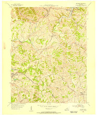
1954 Map of Smithfield
USGS Topo · Published 1955About this map
Louisville and Nashville railroad tracks anchor the landscape of this mid-century survey, connecting a string of small rural communities through the hill country where Henry, Oldham, and Trimble counties meet. The settlement at La Grange serves as a primary hub in the west, while smaller rail-aligned stations like Jericho, Pendleton, and Sulphur suggest the enduring importance of steam and diesel transport for local agriculture. The terrain is deeply dissected by numerous waterways, most notably the Little Kentucky River and the headwaters of Floyds Fork, creating a winding network of ridges and hollows that dictated the placement of early homesteads and cemeteries.
Find a feature on this map
27 named features on this map. Tap any name to fly to it.
Don’t see what you’re looking for? This feature index may not catch every label — zoom into the map to look around manually.
Map Details
Editions of this 1954 Smithfield Map
This is the sole edition of this map. No revisions or reprints were ever made.
Other maps of this area

1928 · New Castle
USGS Topo · 1:48,000

1932 · New Castle
USGS Topo · 1:62,500

1932 · La Grange
USGS Topo · 1:62,500

1939 · Bethlehem
USGS Topo · 1:24,000

1948 · Bethlehem
USGS Topo · 1:24,000

1951 · Crestwood
USGS Topo · 1:24,000

1952 · Campbellsburg
USGS Topo · 1:24,000

1953 · Bedford
USGS Topo · 1:24,000

1953 · Bethlehem
USGS Topo · 1:24,000

1954 · Ballardsville
USGS Topo · 1:24,000