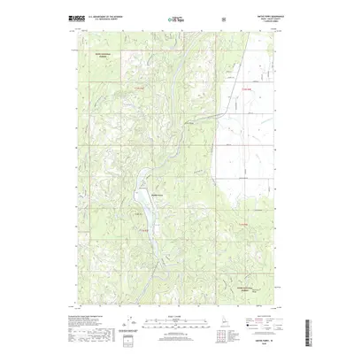
2020 Map of Smiths Ferry
USGS Topo · Published 2020About this map
The North Fork Payette River carves a central path through this section of the Boise National Forest, defining the settlement patterns of Smiths Ferry and the agricultural expanse of Round Valley. The terrain is characterized by significant elevation shifts between the high W Mountain to the west and the North Fork Range to the southeast. Local infrastructure is anchored by the Payette River Scenic Byway, which follows the river's course, connecting smaller access points like Smiths Ferry Dr and Neers Mill Rd. This 2020 record captures the enduring intersection of timberland management and mountain recreation. To the west, Tripod Reservoir and the summit of Cougar Mtn offer glimpses into the rugged geography of Long Valley, while numerous named drainages such as Round Valley Cr and Chipps Cr indicate the complex watershed that feeds the Payette.
Find a feature on this map
53 named features on this map. Tap any name to fly to it.
Don’t see what you’re looking for? This feature index may not catch every label — zoom into the map to look around manually.
Map Details
Editions of this 2020 Smiths Ferry Map
This is the sole edition of this map. No revisions or reprints were ever made.
Other maps of this area

1894 · Squaw Creek
USGS Topo · 1:125,000

1909 · Garden Valley
USGS Topo · 1:125,000

1953 · Smiths Ferry
USGS Topo · 1:62,500

1953 · Boiling Springs
USGS Topo · 1:62,500

1953 · Banks
USGS Topo · 1:62,500

1955 · Baker
USGS Topo · 1:250,000

1957 · Challis
USGS Topo · 1:250,000

1959 · Baker
USGS Topo · 1:250,000

1959 · Garden Valley
USGS Topo · 1:62,500

1960 · Challis
USGS Topo · 1:250,000