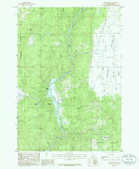
1985 Map of Smiths Ferry
USGS Topo · Published 1986About this map
The North Fork Payette River carves a central path through this mid-1980s topographic study, defining the corridor where the settlement of Smiths Ferry sits. Located along the boundary of the Boise National Forest, the landscape transitions from the steep, timbered slopes of Cougar Mountain and the Tripod Creek drainage into the broader, flatter expanse of Round Valley to the east.
Find a feature on this map
20 named features on this map. Tap any name to fly to it.
Don’t see what you’re looking for? This feature index may not catch every label — zoom into the map to look around manually.
Map Details
Editions of this 1985 Smiths Ferry Map
This is the sole edition of this map. No revisions or reprints were ever made.
Other maps of this area

1894 · Squaw Creek
USGS Topo · 1:125,000

1909 · Garden Valley
USGS Topo · 1:125,000

1953 · Smiths Ferry
USGS Topo · 1:62,500

1953 · Boiling Springs
USGS Topo · 1:62,500

1953 · Banks
USGS Topo · 1:62,500

1955 · Baker
USGS Topo · 1:250,000

1957 · Challis
USGS Topo · 1:250,000

1959 · Baker
USGS Topo · 1:250,000

1959 · Garden Valley
USGS Topo · 1:62,500

1960 · Challis
USGS Topo · 1:250,000