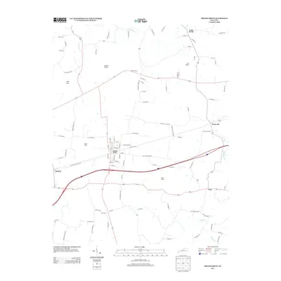
2013 Map of Smiths Grove
USGS Topo · Published 2013About this map
Smiths Grove serves as the central hub of this South-Central Kentucky landscape, showing a dense grid of streets including Broadway Street and Main Street that contrast with the surrounding rural terrain. The geography is defined by prominent elevations such as The Knobs, Pilot Knob, and Little Knob, while the subterranean drainage of the region is suggested by features like Sinking Cr and Little Sinking Cr.
Find a feature on this map
95 named features on this map. Tap any name to fly to it.
Don’t see what you’re looking for? This feature index may not catch every label — zoom into the map to look around manually.
Map Details
Editions of this 2013 Smiths Grove Map
This is the sole edition of this map. No revisions or reprints were ever made.
Other maps of this area

1921 · Bowling Green
USGS Topo · 1:62,500

1922 · Brownsville
USGS Topo · 1:62,500

1922 · Mammoth Cave
USGS Topo · 1:62,500

1923 · Bowling Green
USGS Topo · 1:62,500

1923 · Mammoth Cave
USGS Topo · 1:62,500

1923 · Brownsville
USGS Topo · 1:62,500

1926 · Scottsville
USGS Topo · 1:62,500

1954 · Evansville
USGS Topo · 1:250,000

1954 · Bristow
USGS Topo · 1:24,000
1954 · Brownsville
USGS Topo · 1:24,000