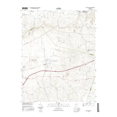
2016 Map of Smiths Grove
USGS Topo · Published 2016About this map
Smiths Grove sits at the heart of this Warren County landscape, showing the town's layout near the intersection of Louisville Rd and several historic routes. The terrain is defined by prominent karst-related features and knobs, including Pilot Knob and The Knobs, which rise above the surrounding sinkholes and intermittent drainages like Sinking Br. The northeastern corner of the map reaches into the southern boundary of Mammoth Cave National Park near Cedar Spring, highlighting the region's unique subterranean hydrology. Local genealogy is well-supported by numerous family-named landmarks and resting places, such as Moon Cem, Hays Cem, and Kinser Cem. The map traces the transitions between small communities like Oakland and Rocky Hill while documenting the intricate network of local roads such as Chalybeate Rd and Knobs Rd that linked these rural settlements in the 21st century.
Find a feature on this map
91 named features on this map. Tap any name to fly to it.
Don’t see what you’re looking for? This feature index may not catch every label — zoom into the map to look around manually.
Map Details
Editions of this 2016 Smiths Grove Map
This is the sole edition of this map. No revisions or reprints were ever made.
Other maps of this area

1921 · Bowling Green
USGS Topo · 1:62,500

1922 · Brownsville
USGS Topo · 1:62,500

1922 · Mammoth Cave
USGS Topo · 1:62,500

1923 · Bowling Green
USGS Topo · 1:62,500

1923 · Mammoth Cave
USGS Topo · 1:62,500

1923 · Brownsville
USGS Topo · 1:62,500

1926 · Scottsville
USGS Topo · 1:62,500

1954 · Evansville
USGS Topo · 1:250,000

1954 · Bristow
USGS Topo · 1:24,000
1954 · Brownsville
USGS Topo · 1:24,000